Transportation Resources
Transportation Resources Available to Communities in the TRO Region
Highway Grant Programs
VTrans Project Documents
Vermont Stream Alteration Permit:
Next Flood Protective Measure Permit (meeting and permit issued onsite)
This permit is an emergency permit where the town meets with the SA Engineer at the site and the Engineer issues a permit onsite after deciding on the appropriate treatments. Next-flood protective measures eligible for coverage under this permit are as follows:
a) Removal of flood-related deposits of instream materials for the purpose of re-creating stream channel conveyance, where failure to do so may threaten public safety or result in severe damage to an improved property;
b) Stream bed or streambank fills necessary to provide access to public facilities or infrastructure or limit further vertical or lateral stream channel movement that would otherwise represent a next-flood threat;
c) Temporary stabilization/restoration of infrastructure to avoid the disruption of services necessary for the protection of public safety or property: and
d) Repair or removal of an existing berm within a flood hazard area or river corridor where the maintenance or removal is necessary to preserve life or prevent severe damage to an improved property.
Emergency Protective Measure Permit (no meeting)
The Emergency Protective Measure authorization process has been designed for when towns cannot meet with the SA Engineer and need an immediate stream alteration permit. Emergency protective measures necessary to preserve life or to prevent the imminent threat of severe damage to public or private property, or both, shall be limited to one or more of the following categories of activity:
a) Removal of flood-related deposits of instream materials for the purpose of re-creating stream channel conveyance;
b) Stream bed or streambank fills necessary to provide access to public facilities or infrastructure or limit further vertical or lateral stream channel movement;
c) Repair of infrastructure, the loss of which would represent an imminent threat to public health and safety; and
d) Temporary berming to protect public safety by preventing stream flows from causing severe imminent damage to an improved property.
- Emergency Protective Measures (EPM) Permit Web Reporting Form
- Guidance for EPM permits (PDF)
- Local Authorization of Emergency In-stream Work in Accordance with Vermont Law– training video
ANR River Management Engineers
Jaron Borg (802) 371-8342 (Bethel, Braintree, Brookfield, Granville, Hancock, Pittsfield, Randolph)
Pat Ross (802) 279-1143 (Bradford, Chelsea, Corinth, Fairlee, Newbury, Strafford, Thetford, Topsham, Tunbridge, Vershire, West Fairlee)
Scott Jensen (802) 490-6932 (Barnard, Bridgewater, Hartford, Hartland, Norwich, Plymouth, Pomfret, Rochester, Royalton, Sharon, Stockbridge, Woodstock)
Statewide City and Village Stormwater Mapping- IDDE (Illicit Discharge Detection and Elimination):
https://dec.vermont.gov/watershed/cwi/manage/idde
Culvert and Bridge Inventories
Town Culverts and Town Bridges under 20′ long
State and Town Bridges over 20′ long
Long Bridge Map
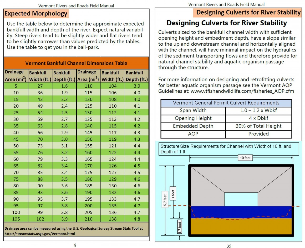
Culvert Sizing
Small culvert for drainage just crossing the road 18” to 36”
- minimum 18 per town road and bridge standards
- Sized according to MRGP Intermittent Stream Culvert Sizing Guidance
Intermediate culverts on streams 36” to 42”-60”
- Sized according to Stream Alteration general permit, VT SA PE can help size
- Watershed Sizing Maps for each town
- Stream Alteration Permit Sizing Requirements pages 11 and 12
- Bankfull width calculations per site are being developed or https://streamstats.usgs.gov/ss/
Large culverts (squish tubes/boxes) > 42” to 60”
Hydraulic studies with Q discharge measurements, done when culvert is being replaced
Municipal Roads General Permit (MRGP)
The Municipal Roads General Permit is intended to achieve significant reductions in stormwater-related erosion from municipal roads, both paved and unpaved. Municipalities will implement a customized, multi-year plan to stabilize their road drainage system. The plan will include bringing road drainage systems up to basic maintenance standards, and additional corrective measure to reduce erosion as necessary to meet a TMDL or other water quality restoration effort. The permit is required by Act 64, the Vermont Clean Water Act, and the Lake Champlain Phase I TMDL.
For more information on the DEC Municipal Roads program and the development of the Municipal Roads General Permit, contact Jim Ryan by email or at (802) 490-6140.
- Final Municipal Roads General Permit
- Response to Comments received during the public comment period.
Municipalities shall complete a Road Stormwater Management Plan (RSWMP) by December 31, 2020. The RSWMP consists of the municipality’s Implementation Table and results of the Road Erosion Inventory.
- Implementation Table – The Department is currently developing the Implementation Table template and when it is complete, it will be posted here.
- Road Erosion Inventory Forms
- Road Erosion Inventory
- Paved Roads with Catch Basins (REI Supplement)
- Paved and Gravel Roads with Drainage Ditches (REI Supplement)
- Road Erosion Inventory
- Sample Plan for Bridgewater
Funding Assistance
Assistance Documents
US Army Corp of Engineers new 2017 General Permit for stream culverts and bridges:
- If you are above any of the permit thresholds listed, you will need to do an application and send an 8.5 x 11 sketch to Essex
- All in-stream work will occur between July 1 and October 1
- No trees ≥3”dbh will need to be cut, no bridge work (compliance with ESA)
- Project involves <200 LF of bank stabilization
- Impacts to waterways/wetlands will be <5000 sq. ft.
- Embedded box culvert with natural bottom material
- Presentation COE-OUTREACH Reg 101
- Permit Resources
- Contacts 802-872-2893
- Michael Adams, [email protected]
- Angela Repella [email protected]
Transportation Damage and Resiliency Planning:
Road Surface Management Software (RSMS) Developed in Maine (table based):
- Tracks road surface condition
- Road and Sign Management Software
Working with Rivers:
VTrans Traffic Data and Town Highway Maps:
Vermont Local Roads Resources:
Municipal Project Management Resources:
- Guidebook for Municipality Managed Projects
- The Orange Book: A Handbook for Local Officials
- Forms for Purchasing and Contracting
- 2019 Better Roads Manual
Improving Infrastructure
Several funding opportunities are available due to the widespread flooding in 2011 to better Vermont’s infrastructure. TRORC successfully applied to and managed several Community Development Block Grants – Disaster Recovery (CDBG-DR) funded by the Department of Housing and Urban Development (HUD) in our member towns of:
- Barnard – Locust Creek Bank Stabilization
- Hancock – Churchville Road culvert replacement
- Stockbridge – Taggart Hill Road relocation
- Rochester – Bean’s Bridge Road Improvements
- Royalton – Gilman Road relocation
- Royalton – South Royalton School flood proofing designs
- Woodstock – Village snow dump relocation
A huge effort after 2011 was to conduct a 12-town culvert inventory. Many of these were funded through Better Roads Grants, which also funds Road Erosion Risk Assessments, culvert replacements, road surface inventories, and capital budgeting to name a few. Having an updated database of culverts in Vermont is pertinent to identify weak spots in a town’s drainage system and actively replace these weak culverts with larger ones to improve resilience against another large rain event.
Funding from the High Meadows Fund created the ‘Quintown Collaborative,’ which includes the towns of Granville, Hancock, Rochester, Stockbridge, and Pittsfield along the Upper White River. This is a grassroots effort to build support for on-the-ground flood resilience projects that will reduce flood damages to these communities and to keep the White River healthy. TRORC partnered with the White River Partnership in this effort, and has received funding to conduct implementation projects! Check out this video detailing the effort.
In partnership with the Upper Valley Adaptation Workgroup, a short instructional video on resiliency strategies was made, watch it here.